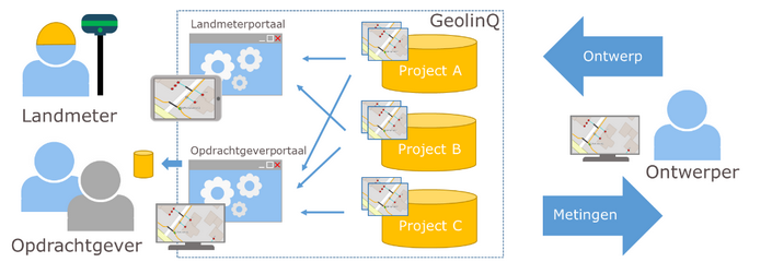
A combination of Global Navigation Satellite System (GNSS) and RTK allows measurements with high precision location determination. GNSS receivers can be integrated with GeolinQ so land surveyors can measure or outline locations based on a planned design using a map on an iPad or other mobile device. The measurement process in GeolinQ is project based and the survey results are for each project real-time available.
For surveying and staking out fiber optic networks, an integration of the UNI-GR1 GNSS receiver from marXact was implemented in collaboration with BAM and Wayss & Freytag. Both companies make intensive use of the application. The actual location of laid fiber optic cables can be easily recorded, and deviations from the original design can be identified. The survey results collected in the field are available in real time at the office for further processing.

“De interface en functionaliteiten maken voor ons écht het verschil.”
Land surveyors can measure locations in the field using an interactive map in combination with a GNSS receiver. GeolinQ supports the following measurement cases:
In GeolinQ the measurement process is organized in projects. Land surveyors can work on multiple measurement projects simultaneously. The measurement results are immediately available and can be shared immediately with the clients.
A project includes:
Measurement projects are centrally stored in GeolinQ so measurement results are immediately available for designers and clients. Interfaces based on WFS services can be configured in order to link to design tools like Geostruct. Clients can view or download the survey results real-time for each project via a map in a client portal.
IntellinQ offers the data management platform GeolinQ for the easy collection, processing, and use of geographical data.